

5 Dec 2018 12 min to read
The Everest Base Camp trek via Gokyo and Cho La Pass is one of the best loop routes in the Khumbu region. Instead of walking up and down the same valley, you climb into the quiet Gokyo Valley, cross the high Cho La Pass (also spelled Chola), and join the classic trail to Everest Base Camp. In one trip you see turquoise glacial lakes, the huge Ngozumpa Glacier, Sherpa villages and four of the world’s 8,000-meter peaks.
The trek starts with a flight from Kathmandu to Lukla (2,860 m). You climb to Namche Bazaar, the Sherpa trading hub, and spend a day acclimatizing. From there you leave the main trail and follow the Gokyo Valley through Dole and Machhermo to the Gokyo Lakes at about 4,790 m. Most trekkers climb Gokyo Ri (5,357 m) for a sunrise view of Everest, Lhotse, Makalu and Cho Oyu.
The hardest day comes next: crossing Cho La Pass (5,420 m). Beyond it you reach Dzongla and Lobuche, then continue to Gorak Shep, Everest Base Camp (5,364 m) and Kala Patthar (5,545 m). The return goes via Pheriche, Pangboche, Tengboche and Namche Bazaar.
Trek at a glance
In this guide

The trade-off is extra days, extra cost, and one demanding pass crossing. If you have less time, see our Shortest 6-day Everest view trek or Everest Base Camp Trek with Helicopter Return from Gorakshep.
This is a sample plan. Your operator may adjust it for weather and how well the group is acclimatizing.
| Day | Route | Walking time | Sleeping altitude |
|---|---|---|---|
| 1 | Fly Kathmandu to Lukla, trek to Phakding | 3–4 hrs | 2,610 m |
| 2 | Phakding to Namche Bazaar | 5–6 hrs | 3,440 m |
| 3 | Acclimatization day in Namche | Short hike | 3,440 m |
| 4 | Namche to Dole | 5–6 hrs | 4,040 m |
| 5 | Dole to Machhermo | 3–4 hrs | 4,470 m |
| 6 | Machhermo to Gokyo | 4–5 hrs | 4,790 m |
| 7 | Gokyo rest day, climb Gokyo Ri | 3–4 hrs | 4,790 m |
| 8 | Gokyo to Thangnak | 3–4 hrs | 4,700 m |
| 9 | Thangnak to Dzongla via Cho La Pass | 7–9 hrs | 4,830 m |
| 10 | Dzongla to Lobuche | 2–3 hrs | 4,910 m |
| 11 | Lobuche to Gorak Shep, visit Everest Base Camp | 6–7 hrs | 5,164 m |
| 12 | Kala Patthar sunrise, descend to Pheriche | 6–7 hrs | 4,371 m |
| 13 | Pheriche to Tengboche via Pangboche | 5–6 hrs | 3,860 m |
| 14 | Tengboche to Namche Bazaar | 5–6 hrs | 3,440 m |
| 15 | Namche Bazaar to Lukla | 6–7 hrs | 2,860 m |
| 16 | Fly Lukla to Kathmandu | 30 min flight | — |
Add one or two spare days at the end. Lukla flights are often delayed by weather.
After Namche Bazaar, the trail turns north into the Gokyo Valley. Villages are fewer, the views open up, and the trail runs beside the Dudh Koshi River, then along the edge of the Ngozumpa Glacier, the longest glacier in the Himalayas.
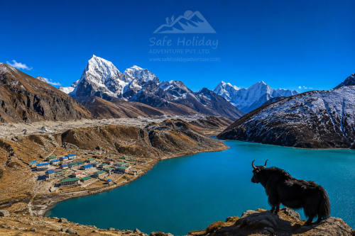
The Gokyo Lakes are a chain of glacial lakes. The third lake, Dudh Pokhari, is the largest and the most photographed, and it reflects the surrounding peaks on calm mornings. You sleep beside it in the village of Gokyo.
The climb to Gokyo Ri (5,357 m) takes about 3 to 4 hours from the village. It is steep but not technical. From the top you see Everest, Lhotse, Makalu and Cho Oyu, plus the lakes and glacier below. Start before dawn for the best light and the calmest wind.
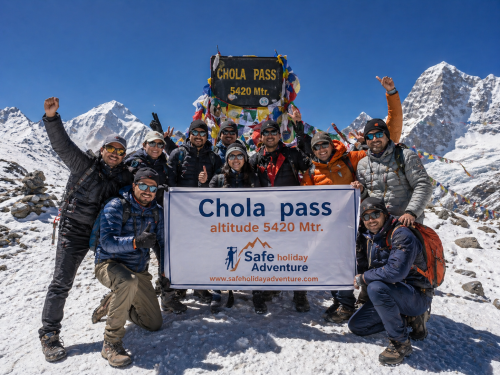
Cho La Pass (5,420 m) is the hardest day of the Everest Base Camp trek via Gokyo and Cho La Pass. Expect 7 to 9 hours of walking from Thangnak to Dzongla.
Safety tips for Cho La
From Dzongla, the trail joins the main route near Lobuche, and the trek becomes more crowded. You continue to Gorak Shep (5,164 m), then walk to Everest Base Camp (5,364 m). You see the Khumbu Icefall, the Khumbu Glacier, and the walls of Nuptse. You cannot see the summit of Everest from the base camp itself.
The classic view comes the next morning from Kala Patthar (5,545 m), a black rocky ridge above Gorak Shep. At sunrise, Everest, Lhotse and Nuptse glow orange above the glacier. Start before dawn and wear your warmest layers.
After Kala Patthar, the trail goes down to Pheriche, then on to Pangboche and Tengboche. This is the greenest part of the trek, and it gives some of the best views of Ama Dablam.
From Tengboche the trail drops to the Dudh Koshi River and climbs back to Namche Bazaar. Then it’s a long day to Lukla for your flight to Kathmandu.
| Season | Months | What to expect |
|---|---|---|
| Spring | March–May | Rhododendrons bloom, days are longer, and the trail is busy. Cold nights at altitude. |
| Monsoon | June–August | Rain, cloud, leeches on the lower trail and slippery paths. Not recommended for Cho La. |
| Autumn | September–November | Clear skies and stable weather. October is the busiest month. |
| Winter | December–February | Very cold (nights well below −10°C), snowy trails and closed teahouses. Cho La can be impassable. |
March–May and late September–November are best for the Everest Base Camp trek via Gokyo and Cho La Pass. Temperatures vary by year and altitude, so check the forecast with your operator before you go.
1. How many days does the trek take?
Most itineraries take 15 to 18 days, including acclimatization days. Add a spare day or two for Lukla flight delays.
2. How difficult is the Gokyo and Cho La Pass trek?
It is strenuous. No technical climbing is needed, but the days are long, the altitude is high and the pass can be icy.
3. How hard is the Cho La Pass crossing?
It is the hardest day of the trek, taking 7 to 9 hours from Thangnak to Dzongla. Expect rocky slopes and an icy glacier section near the top.
4. How high is Cho La Pass?
About 5,420 m (17,782 ft). It is the highest point on the route apart from Kala Patthar (5,545 m).
5. Is Cho La Pass dangerous?
It is manageable in good weather with a guide, but it can be risky after snowfall. Start early and turn back if conditions look unsafe.
6. What is the best time to do this trek?
March to May and late September to November. These months have the clearest skies and the most stable weather.
7. Can I do the Cho La Pass in winter or monsoon?
It’s not recommended. Winter brings heavy snow and extreme cold, and the monsoon brings rain, cloud and slippery trails.
8. Which is better, Gokyo Ri or Kala Patthar?
They offer different views. Gokyo Ri shows four 8,000 m peaks and the lakes, and Kala Patthar gives the classic close-up of Everest. This route gives you both.
9. Do I need a guide for Cho La Pass?
It is strongly recommended. A guide helps with route-finding, weather decisions and safety on the icy section.
10. What permits do I need?
A Sagarmatha National Park permit and a Khumbu local (rural municipality) permit. Your agency can arrange both.
11. Is this trek better than the standard Everest Base Camp trek?
It is quieter and more varied, with lakes, a high pass and a loop route. It also takes longer, costs more and is harder.
12. How do I avoid altitude sickness?
Walk slowly, rest at Namche Bazaar and Gokyo, and drink 3 to 4 litres of water a day. Never ascend with worsening symptoms.
13. What gear do I need for Cho La Pass?
Waterproof boots, trekking poles, warm layers, a four-season sleeping bag and a headlamp. Add microspikes for icy conditions.
14. Can beginners do this trek?
Fit first-time trekkers can do it, but the standard Everest Base Camp trek is an easier start. This route suits people with some multi-day trekking experience.
15. Do I need travel insurance?
Yes. Choose a policy that covers trekking up to at least 6,000 m and helicopter evacuation.
The Everest Base Camp trek via Gokyo and Cho La Pass combines the Gokyo Lakes, a high Himalayan pass and Everest Base Camp in a single loop. It is tougher and longer than the standard route, but it rewards you with quieter trails, more variety, and unforgettable views.
Ready to plan it? Contact Safe Holiday Adventure for a customized itinerary, permits and an experienced guide. You can also explore:
There is a moment on every Everest trek when your legs have an opinion. For most people, it arrives
Continue Reading
If you are asking how difficult the Everest Three Passes Trek is, the honest answer is this: it is t
Continue Reading
My name is Peng Chang, and I travelled to Nepal from Malaysia with a small group of friends. Before
Continue Reading
In this story Why I Chose Everest Base Camp My name is Chyling, and I come from Malaysia, a country
Continue Reading
Ask anyone who has finished the Annapurna Circuit which day they remember most, and the answer is al
Continue Reading
Introduction Kathmandu doesn’t ease you in. You step out of the airport into a chorus of horns
Continue Reading