

28 Sep 2018 12 min to read
If you’re planning an Upper Mustang trek, you’re choosing one of the most distinctive walking routes in Nepal. Tucked behind the Annapurna range, in the rain shadow of the Himalayas, Upper Mustang is a high-altitude desert of red cliffs, wind-carved canyons, whitewashed monasteries, and a walled royal city that stayed closed to outsiders until 1992. For travelers who want a trek that feels genuinely different from the crowded trails of Everest or Annapurna, this region delivers something rare: silence, space, and centuries of untouched Tibetan Buddhist culture.
This guide covers everything you need to plan an Upper Mustang trek — permits, best season, route, difficulty, cost, and answers to the questions trekkers ask most.
An Upper Mustang trek isn’t about towering peaks up close; it’s about landscape and culture. The trail winds through a high desert plateau that resembles Tibet more than Nepal, with eroded canyons, cave dwellings carved into cliffs thousands of years ago, and villages that have preserved their Tibetan-influenced way of life largely undisturbed.
Because the region only opened to foreign trekkers in the early 1990s, and still requires a restricted area permit, it sees a fraction of the foot traffic of other classic Nepal treks. That means quieter trails, more personal encounters with local communities, and a stronger sense of discovery than you’ll find on more commercial routes like the Everest Base Camp trek.
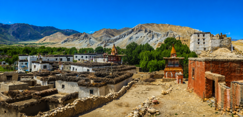
Upper Mustang sits in a rain shadow, which makes it one of the few Nepal treks that’s genuinely enjoyable during the monsoon. The main windows are:
Winter (December–February) is possible but brutally cold and windy, with many teahouses closing, so it’s rarely recommended for this particular trek.
Upper Mustang is a restricted area, so its permit process differs from most other Nepal treks:
Because of these rules, an Upper Mustang trek can’t be done solo or without a registered agency — one of the few remaining treks in Nepal with this restriction, and part of why the region has stayed so well preserved. You can check current permit rules directly on Nepal’s official tourism board website.

Day 1: Kathmandu to Pokhara
Fly or drive from Kathmandu to Pokhara (820m). This scenic lakeside city is the launch point for the trek and a good place to double-check permits and gear before heading into the restricted area.
Day 2: Pokhara to Jomsom, trek to Kagbeni
A short scenic flight takes you from Pokhara to Jomsom (2,720m), following the Kali Gandaki Gorge — one of the deepest gorges in the world. From Jomsom, trek roughly 3 hours to Kagbeni (2,800m), the last checkpoint before entering the restricted Upper Mustang region.
Day 3: Kagbeni to Chele
This is where the Upper Mustang trek officially begins. Trek 5–6 hours through Tangbe village and along the Kali Gandaki riverbed to reach Chele (3,050m), passing your first red-cliff formations and eroded canyon walls.
Day 4: Chele to Syangboche
A tougher day: climb steeply out of Chele over the Taklam La pass (3,624m) before descending to Syangboche (3,800m). Around 6–7 hours of walking, with your first real taste of Mustang’s high desert terrain.
Day 5: Syangboche to Ghami
Cross two more passes — Yamda La (3,850m) and Bhena La (3,850m) — before dropping into Ghami (3,520m), one of the larger villages in the region. Roughly 5–6 hours of walking through increasingly stark, wind-sculpted landscape.
Day 6: Ghami to Charang
A shorter, 4-hour day passing the longest mani wall (a Buddhist prayer wall) in Nepal, before reaching Charang (3,560m), home to a red monastery and the ruins of an old fort overlooking the valley.
Day 7: Charang to Lo Manthang
Trek 4–5 hours over the Lo La pass (3,950m), where you’ll get your first view of the walled city of Lo Manthang (3,840m) in the valley below — one of the most memorable moments of the trek.
Day 8: Explore Lo Manthang
A full rest-and-exploration day inside the walled city. Visit the former royal palace, the four major gompas (Jampa, Thubchen, Chodie, and Choprang), and walk the narrow alleyways of Nepal’s last forbidden kingdom. Most trekkers also arrange a side trip to nearby caves or the hilltop viewpoint above the city.
Day 9: Lo Manthang to Ghar Gompa via Drakmar
Take the alternate return route through Drakmar, known for its dramatic red cliffs, and visit Ghar Gompa, one of the oldest and most sacred monasteries in the region, older than Lo Manthang itself. Around 5–6 hours of walking.
Day 10: Ghar Gompa to Chuksang
Descend back toward the Kali Gandaki valley, passing through Tsarang and rejoining the main trail near Chuksang (2,980m). This is typically a long day of 6–7 hours as the return route partially retraces the outward path.
Day 11: Chuksang to Jomsom
Trek back through Kagbeni and along the riverbed to Jomsom (2,720m), roughly 5–6 hours, marking your exit from the restricted area.
Day 12: Jomsom to Pokhara
Fly back to Pokhara. With a free afternoon, most trekkers use this day to relax by Phewa Lake after nearly two weeks in the high desert.
Day 13: Pokhara to Kathmandu
Fly or drive back to Kathmandu.
Day 14: Departure
Buffer day for delayed mountain flights (common in this region due to wind) or onward international travel.
Notes for shorter or longer versions:
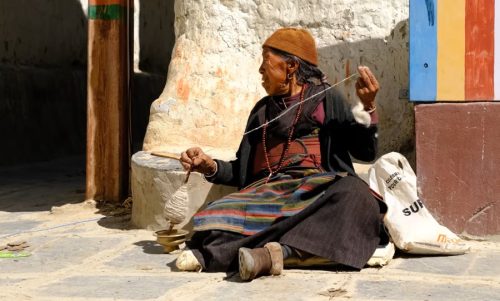
Lo Manthang is the reason most people choose an Upper Mustang trek over other options. Founded in the 15th century, this walled city was the capital of the independent Kingdom of Lo, and it still feels like stepping into a different century. Inside the mud-brick walls, you’ll find:
Most itineraries build in a full rest-and-explore day here, which is worth every hour — rushing through Lo Manthang is the most common regret trekkers report afterward.
An Upper Mustang trek is considered moderate in difficulty. The trails involve steady walking of 5–7 hours a day, with some steep, exposed sections and constant wind, but there’s no technical climbing and altitude gain is gradual — the highest point, Lo Manthang, sits around 3,800 meters. The bigger challenges are the dry, dusty climate and strong afternoon winds rather than extreme elevation, which makes this trek accessible to trekkers with reasonable fitness and some prior hiking experience.

If you’re weighing an Upper Mustang trek against Nepal’s other restricted-area routes, here’s how it compares:
Because Mustang is a high desert with dramatic temperature swings and near-constant wind, packing differs slightly from greener Nepal treks:
An Upper Mustang trek tends to be pricier than other Nepal treks mainly because of the restricted area permit. A rough breakdown:
All-inclusive packages through a trekking agency typically range from USD 1,800 to USD 2,800 per person, depending on group size, trip length, and season.
1. How long is the Upper Mustang trek?
Most itineraries run 10–14 days from Kathmandu and back, including flights to and from Jomsom.
2. How far do you walk each day?
Typically 12–18 km per day, translating to 5–7 hours of walking depending on terrain and passes.
3. What’s the highest point of the trek?
Lo Manthang and the surrounding passes sit around 3,800–3,950m, making this a moderate-altitude trek rather than a high-altitude one.
4. Is Upper Mustang open all year?
Yes, but winter (Dec–Feb) sees extreme cold and closed teahouses, so most trekkers avoid that window.
5. Why is Upper Mustang trekkable during monsoon?
It sits in a rain shadow behind the Annapurna range, so it stays dry even when the rest of Nepal is flooded with monsoon rain.
6. How do you get to Upper Mustang?
Fly from Kathmandu to Pokhara, then Pokhara to Jomsom, followed by a road or trekking route to Kagbeni, the entry point.
7. What is the Restricted Area Permit fee?
USD 500 per person for the first 10 days, plus USD 50 for each additional day, payable only through a registered trekking agency.
8. Can you trek Upper Mustang independently?
No — a licensed guide and a minimum group of two trekkers are legally required due to the restricted area status.
9. What’s the significance of Lo Manthang?
It was the walled capital of the independent Kingdom of Lo, ruled by its own king until the Nepali government formally ended the monarchy’s status in 2008.
10. What are the Sky Caves of Mustang?
Thousands of man-made caves carved into cliff faces, some over 2,000 years old, believed to have served as tombs, meditation retreats, or storage.
11. Is there mobile network coverage in Upper Mustang?
Coverage is patchy and unreliable past Kagbeni, with better signal in larger villages like Ghami and Lo Manthang.
12. What kind of accommodation is available?
Basic teahouses with shared rooms and squat toilets are the norm — comfort is simpler here than on more touristed Nepal treks.
13. What food is typically available on the trail?
Dal bhat, noodles, momos, and Tibetan bread are staples, with fewer menu options than in Everest or Annapurna teahouses.
14. Do you need travel insurance for this trek?
Yes — insurance covering trekking up to at least 4,000m and emergency evacuation is strongly recommended.
15. What wildlife might you see in Upper Mustang?
Blue sheep, Himalayan marmots, and occasionally snow leopards or their tracks in the more remote side valleys.
16. Is Upper Mustang good for photography?
Extremely — the combination of red-ochre cliffs, prayer flags, whitewashed monasteries, and stark desert light makes it one of Nepal’s most photogenic regions.
17. What festivals happen in Upper Mustang?
The Tiji Festival, a three-day masked-dance ritual held in Lo Manthang each May, is the region’s most famous cultural event.
18. How does trekking here affect local communities?
Permit fees are intended to fund local development and conservation, making tourism one of the region’s main sources of income.
19. What should you avoid packing?
Heavy cotton clothing — it holds moisture and dust poorly in this dry, windy climate; synthetic or wool layers work far better.
20. Can you combine Upper Mustang with another trek?
Yes — it’s often paired with a short Annapurna Circuit or Muktinath side trip, since both share the same Jomsom access route.
An Upper Mustang trek rewards travelers looking for something beyond the well-worn trails — a landscape of ochre cliffs and ancient cave monasteries, and a living culture that has changed little in centuries. It takes more planning and costs more in permits than most Nepal treks, but for many, that’s exactly what makes it worth it.
There is a moment on every Everest trek when your legs have an opinion. For most people, it arrives
Continue Reading
If you are asking how difficult the Everest Three Passes Trek is, the honest answer is this: it is t
Continue Reading
My name is Peng Chang, and I travelled to Nepal from Malaysia with a small group of friends. Before
Continue Reading
In this story Why I Chose Everest Base Camp My name is Chyling, and I come from Malaysia, a country
Continue Reading
Ask anyone who has finished the Annapurna Circuit which day they remember most, and the answer is al
Continue Reading
Introduction Kathmandu doesn’t ease you in. You step out of the airport into a chorus of horns
Continue Reading