STAY CONNECTED![]()
![]()
![]()
![]()
Government Licence No.: 131483/071/072
STAY CONNECTED![]()
![]()
![]()
![]()
September 22, 2025

The Thorong La Pass trek is widely regarded as one of the most thrilling and rewarding treks in Nepal. Standing at 5,416 meters above sea level, Thorong La is the highest point of the Annapurna Circuit Trek and draws trekkers from all over the world. This journey offers a combination of high-altitude adventure, cultural exploration, and breathtaking Himalayan scenery. From lush green valleys to arid high-altitude landscapes, trekkers experience a remarkable diversity of terrains, climates, and cultures.
The Annapurna Circuit Trek has long been a bucket-list adventure, providing an immersive experience into the natural beauty and cultural richness of Nepal. The trek typically begins at Besisahar, following the Marsyangdi River, and passes through hills, valleys, and villages before reaching high Himalayan regions. The Thorong La Pass itself is a challenge that requires proper acclimatization, preparation, and mental resilience.
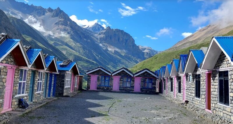
Clear blue sky and mounatin view from ledar , manang
The Thorong La Pass and the Annapurna Circuit offer breathtaking landscapes and unique trekking experiences throughout the year. However, the optimal trekking periods are during the spring (March–May) and autumn (September–November) seasons.
Autumn (September–November):
Weather: Clear skies with stable, dry conditions.
Views: Panoramic mountain vistas of Annapurna, Dhaulagiri, and Machapuchhre.
Advantages: Ideal visibility for photography, moderate trekking conditions, and minimal risk from landslides or leeches.
Spring (March–May):
Weather: Mild temperatures with generally clear skies.
Views: Snow-capped peaks combined with vibrant rhododendron blooms.
Advantages: Pleasant trekking conditions and colorful landscapes.
Winter (December–February):
Weather: Cold temperatures, especially above 4,000 m, with possible snow on Thorong La.
Considerations: Fewer trekkers and clear skies, but very cold nights and limited teahouse availability.
Monsoon (June–August):
Weather: Heavy rainfall, cloud cover, and potential landslides.
Considerations: Poor visibility, slippery trails, increased risk from leeches, and limited tea house operations. Trekking during this period is not recommended.
For the best overall trekking experience, autumn (September–November) is highly recommended, followed by spring (March–May).
Monsoon trek
A typical Annapurna Circuit trek with Thorong La Pass can take 14–21 days, depending on the chosen route and acclimatization schedule. Here is a step-by-step outline:
Day 1: Besisahar to Bhulbhule – Begin your journey along the Marsyangdi River, walking through lush forests and small villages. Trekking distance: 8–9 km, duration 4–5 hrs.
Day 2: Bhulbhule to Jagat – Pass through waterfalls, terraced fields, and traditional villages. Trek distance: 15 km, 6–7 hrs.
Day 3: Jagat to Dharapani – Cross forests and scenic valleys, experiencing the local lifestyle. Trek distance: 20 km, 7–8 hrs.
Day 4: Dharapani to Chame – Enter high-altitude landscapes, traditional Thakali villages. Trek distance: 15 km, 5–6 hrs.
Day 5: Chame to Upper Pisang – Enjoy panoramic mountain views, including Annapurna II and Chugkar viewpoint. Trek distance: 12 km, 5–6 hrs.
Day 6: Upper Pisang to Manang – Experience high-altitude valleys and cultural monasteries. Trek distance: 12 km, 5–6 hrs.
Day 7: Rest/Acclimatization in Manang – Acclimatize with hikes to Gangapurna Lake or local viewpoints.Day 8: Manang to Yak Kharka – Trek through alpine meadows and yak pastures. Distance: 10 km, 4–5 hrs.
Day 9: Yak Kharka to Thorong Phedi – Prepare for the pass; snowy and rocky terrains dominate. Distance: 7 km, 3–4 hrs.
Day 10: Thorong La Pass to Muktinath – Cross the 5,416m pass early morning, descend to Muktinath. Distance: 20 km, 8–10 hrs.
Day 11: Muktinath to Jomsom – Walk along the Kali Gandaki valley, enjoying Mustang-like landscapes. Distance: 20 km, 6–7 hrs.
Day 12: Jomsom to Pokhara (Flight) – Relax and take a scenic flight back to Pokhara, reflecting on the journey.
Alternative side trips, such as Tilicho Lake or Mustang region detours, can be added for more adventure and diverse landscapes.
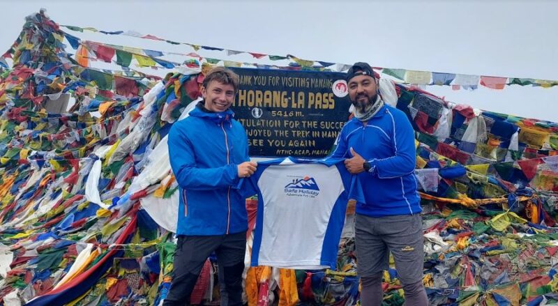
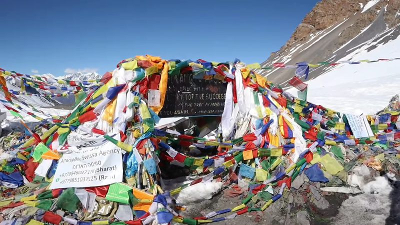
Reached the top of Thorong La Pass (5416meters
Thorong La Pass (5,416 m) is the highest point of the Annapurna Circuit Trek. Proper planning is essential for a safe and enjoyable crossing.
A. From Thorong Phedi (4,450 m) to Thorong La Pass (5,416 m)
Distance: ~6 km
Approximate Trekking Time: 5–6 hours
Details: The trail is steep and rocky, with significant altitude gain (~966 m). Trekking from Thorong Phedi requires careful pacing and short breaks to prevent fatigue and altitude sickness.
B. From High Camp (4,900 m) to Thorong La Pass (5,416 m)
Distance: ~2.5–3 km
Approximate Trekking Time: 2.5–3 hours
Details: High Camp is the most common last stop before the pass. The ascent is shorter but steep, with spectacular views. Starting from here allows for a more relaxed morning compared to beginning at Thorong Phedi.
From High Camp: 4:30–5:00 AM
From Thorong Phedi: 3:30–4:00 AM
Rationale: An early departure ensures you reach the pass before strong winds, increased crowding, and direct sunlight. It also allows sufficient time for acclimatization and rest breaks.
Dress in warm, layered clothing, and carry gloves, a hat, and trekking poles.
Carry sufficient water and light snacks for energy.
Maintain a steady, slow pace to manage altitude changes.
Take frequent short rests to reduce fatigue.
Aim to reach the pass by mid-morning to enjoy the views and safe trekking conditions.
Thorong La Pass (5,416 m) is often covered with snow during the late autumn and winter months. From late October to early December, you may see the first snowfall, making the mountains white and spectacular. Snow can also appear again from late January to March, especially after fresh snowfalls, creating a beautiful but colder trekking experience.
Trekkers should be prepared for icy paths and cold winds during these months. Proper gear like warm clothing, trekking boots, and walking poles is essential. Snow on the pass adds to the adventure and offers breathtaking panoramic views of the Annapurna and Dhaulagiri ranges, making the trek unforgettable.
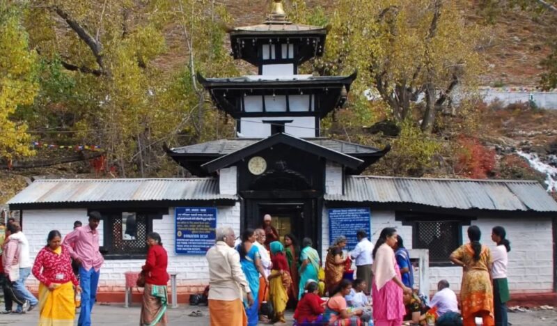
Muktinath Temple
After crossing Thorong La Pass (5,416 m) early in the morning, trekkers start the descent to Muktinath (3,710 m). The total distance is about 20 km, and it usually takes 7–9 hours to complete, depending on your pace.
The trail first goes down to High Camp (4,200 m), then to Thorong Phedi (4,540 m). You will pass Yak Kharka (3,900 m) and Ranipauwa (3,700 m) along the way. The trail is a mix of rocky paths, small streams, and alpine landscapes, gradually changing to pine and rhododendron forests as you descend.
A good place to stop for lunch is Ranipauwa, about halfway from the pass. Here, you can enjoy simple Nepali meals in a tea house while resting before the final descent. The trail then continues gently to Muktinath, where you can visit the famous Muktinath Temple and enjoy the peaceful surroundings.
This route offers breathtaking views of Annapurna, Dhaulagiri, and Nilgiri mountains along the way, making it one of the most memorable sections of the Annapurna Circuit.
The Thorong La Pass trek requires careful acclimatization. High-altitude trekking carries the risk of acute mountain sickness (AMS), which can include headaches, nausea, dizziness, and fatigue. To minimize risk:
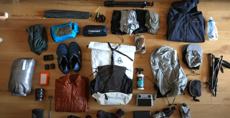
Trekking gear list for ABC trekking in nepal
Proper gear ensures comfort, safety, and success. Essentials include:
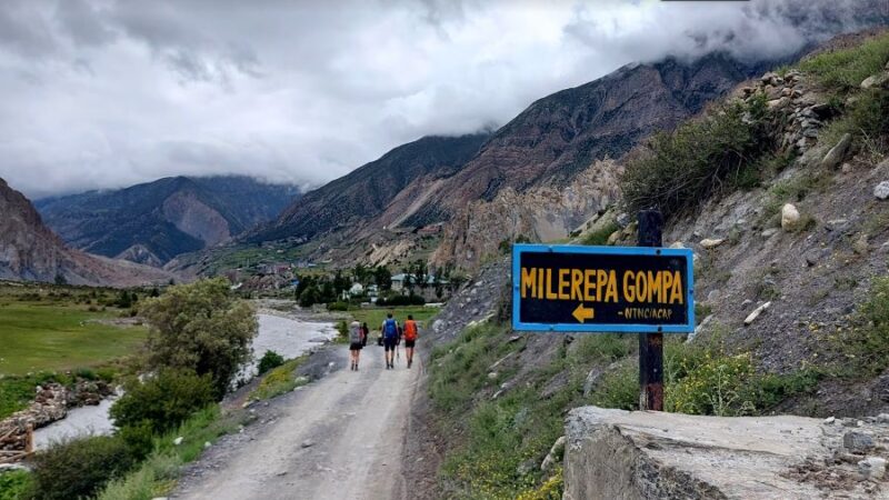
Jagat and Dharapani are the first major villages trekkers encounter on the Annapurna Circuit. These villages are set in lush subtropical valleys, where the landscape is dominated by green terraced rice fields, orange orchards, and dense forests. The villages are vibrant, with traditional Nepali houses made of stone and wood. Here, trekkers get their first taste of local life, seeing villagers farming, tending livestock, and performing daily chores. Local teahouses offer simple meals, warm hospitality, and a chance to interact with families who have lived here for generations.
Chame, the district headquarters of Manang, and Upper Pisang are key stops for acclimatization and cultural immersion. Both villages are predominantly home to the Thakali people, an ethnic group known for their distinct cuisine, warm hospitality, and rich traditions. Trekkers can explore traditional stone and wood houses, Buddhist prayer flags, and small monasteries. Upper Pisang, in particular, offers stunning views of Annapurna II and Pisang Peak while also providing an authentic experience of Thakali festivals, local dances, and culinary delights like Thakali thali (a platter of rice, lentils, vegetables, and pickles).
Manang is a cultural and trekking hub situated high in the mountains. The village is famous for its well-preserved monasteries, prayer wheels, and traditional stone houses with wooden windows. Here, trekkers can explore narrow streets, interact with monks, and sample local specialties such as yak cheese, butter tea, and lentil pancakes. Manang also has a rich tradition of handicrafts and weaving, allowing visitors to purchase authentic souvenirs. The area’s cultural depth is enhanced by the blending of Tibetan and Nepali influences, reflected in festivals, religious practices, and daily life.
Muktinath is one of the most sacred destinations along the Annapurna Circuit. The village is renowned for the Muktinath Temple, an important pilgrimage site for both Hindus and Buddhists, and the sacred 108 water spouts (Muktidhara) where pilgrims perform ritual baths. The village sits at a high altitude, providing trekkers with stunning views of the Mustang region and the Annapurna peaks. Visiting Muktinath offers a unique spiritual and cultural experience, with the chance to witness pilgrims from across Nepal and India performing rituals, chanting prayers, and showing deep devotion.
These villages along the Annapurna Circuit provide more than just a stopover—they offer authentic cultural experiences, interactions with local communities, and a deep understanding of Nepali traditions. From terraced farms in Jagat to sacred rituals in Muktinath, each village tells its own story, making the Annapurna Circuit a journey of both natural beauty and cultural discovery.

Nepali local Food- Dhal Bhat
Food along the Annapurna Circuit trek is generally available in teahouses and lodges, and the variety improves as you pass through larger villages. Trekking in Nepal offers both traditional local cuisine and some international options.
1. Local Nepali Food:
Dal Bhat – This is the staple meal: lentil soup served with rice, seasonal vegetables, and sometimes chicken, fish, or buffalo meat. It is filling and provides good energy for long trekking days.
Thukpa – A Tibetan-style noodle soup with vegetables or meat, ideal for warming up at high altitudes.
Momos – Steamed or fried dumplings filled with vegetables, chicken, or buffalo meat.
Aloo Tama, Gundruk Soup – Fermented bamboo and leafy vegetable soups, more common in mid-hill villages.
2. International Options:
Many teahouses cater to trekkers with options like pasta, noodles, fried rice, pizza, and pancakes. Tea, coffee, hot chocolate, and fresh juices are widely available, though sometimes at higher altitudes, prices increase due to transportation costs.
3. Special Considerations:
Vegetarians and vegans will find dal bhat, rice, potatoes, and vegetables easy to manage, though options like cheese, eggs, and dairy are more common in mid-hill lodges.
Water should always be treated or boiled; most lodges offer boiled or filtered water for a small fee.

Bamboo Village
Accommodation on the trek is primarily in teahouses, which are small lodges offering basic but comfortable rooms. The quality varies depending on altitude and remoteness.
1. Lower and Mid-Hill Villages:
Villages like Ghorepani, Chame, and Manang have well-established teahouses.
Rooms usually have single or double beds with blankets; some lodges provide hot showers for an extra fee.
Electricity and Wi-Fi may be available in larger villages, but can be intermittent.
2. High-Altitude Villages:
Above Thorong La Pass, lodges become more basic. Rooms may be smaller, heated with wood stoves, and sometimes you may need to share a bathroom.
Hot water may be limited, and electricity may only be available via solar panels.
3. Amenities and Services:
Common areas are cozy for dining and socializing.
Some lodges provide charging for devices at a small fee.
Most lodges have friendly staff and offer blankets and pillows; trekkers often carry a sleeping bag for extra warmth at higher altitudes.
4. Booking Tips:
During peak seasons (autumn and spring), it’s advisable to arrive early at lodges to secure rooms, especially in smaller villages.
Prices for food and accommodation increase with altitude, so budgeting accordingly is important.
Overall, the Annapurna Circuit offers a good balance of comfort and local flavor. Trekkers can enjoy hearty Nepali meals and safe, clean lodging throughout the trek, with a gradual adjustment in facilities as the altitude increases.
Adventurous trekkers can explore:
Physical preparation is essential:
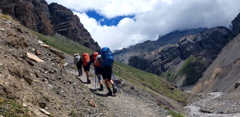
Way to Manang
The Annapurna region has a rich variety of plants and animals, changing with altitude:
Lower Valleys (Subtropical Zone): Lush forests with rhododendrons, oaks, and pines. These areas are vibrant and full of green life.
Mid-Hills (Temperate & Alpine Zone): Fir, juniper, and mixed forests dominate. You will also find a variety of shrubs and wildflowers.
High Altitude (Above 4,000 m): Vegetation becomes sparse, with mosses, lichens, and hardy alpine plants that survive the cold.
Wildlife: The region is home to animals like the Himalayan monal (national bird), blue sheep, snowcocks, and in very remote areas, you might even spot red pandas.
After the challenging yet rewarding trek over Thorong La Pass (5,416 m / 17,769 ft) on the Annapurna Circuit, many trekkers continue to the sacred Muktinath Temple, a revered site for both Hindus and Buddhists. This temple, located at 3,710 m (12,172 ft) in the Mustang region of Nepal, is considered a place of liberation and spiritual cleansing.
The path from Thorong La High Camp to Muktinath offers breathtaking landscapes, including views of Dhaulagiri, Nilgiri, and Annapurna ranges, high-altitude desert terrain, and the Mustang valley’s unique Himalayan culture. The descent is steep and requires careful trekking, but the sense of accomplishment grows as you approach the temple.
Muktinath Temple is famous for its 108 natural water spouts and eternal flame, symbolizing purity and eternal life. Pilgrims perform rituals such as walking under the holy water spouts or offering prayers to cleanse their sins and seek blessings. Many trekkers experience a deep sense of peace and spiritual fulfillment when visiting this sacred site after the physical and mental challenge of Thorong La Pass.
Staying in nearby Muktinath village allows trekkers to rest, enjoy local cuisine, and immerse themselves in the spiritual ambiance before continuing the descent toward Jomsom or Marpha, completing the next stage of the Annapurna Circuit.
Highlights of the spiritual journey:
Crossing Thorong La Pass and witnessing sunrise over snow-capped peaks.
Descending through dramatic landscapes toward Muktinath.
Visiting the sacred Muktinath Temple with its holy water spouts and eternal flame.
Experiencing spiritual serenity and local cultural traditions.
Opportunity to rest in Muktinath village and prepare for the continuation of the trek.
The Annapurna Circuit Trek offers breathtaking views, charming villages, and unforgettable experiences. Trekking this route can be done in two directions: clockwise or counterclockwise. Each choice has its own advantages.
Clockwise Route: Many trekkers prefer this direction as it allows easier acclimatization, a gradual climb, and stunning sunrise views of Annapurna peaks from Thorong La Pass.
Counterclockwise Route: This route is less crowded and offers a unique perspective of the mountains and villages. It can be more challenging at the beginning, but the descent toward the end is gentle and rewarding.
Choosing the right direction depends on your fitness, schedule, and what kind of experience you want. Both routes promise incredible landscapes, rich culture, and memories that last a lifetime.
Take your time: Ascend slowly to give your body time to adjust to lower oxygen levels.
Follow “climb high, sleep low”: Hike to a higher altitude during the day but sleep at a lower one if possible.
Listen to your body: If you feel a severe headache, dizziness, nausea, or breathlessness, stop and rest or descend.
Mild Acute Mountain Sickness (AMS): Headache, nausea, loss of appetite, fatigue, dizziness.
Severe AMS: Vomiting, confusion, inability to walk straight.
High-Altitude Pulmonary Edema (HAPE): Shortness of breath even at rest, cough with frothy or pink sputum, weakness.
High-Altitude Cerebral Edema (HACE): Severe headache, confusion, loss of coordination, hallucinations.
Action: Descend immediately if symptoms are severe.
Drink plenty of water (3–4 liters per day) to prevent dehydration.
Eat high-energy foods like nuts, chocolate, bread, and fruits.
Avoid excessive alcohol and caffeine, as they can worsen dehydration and altitude sickness.
Layer clothing to manage cold and wind: base layer, insulation layer, and waterproof outer layer.
Use good-quality trekking boots with grip.
Carry essentials: hat, gloves, sunglasses, sunscreen, trekking poles, first-aid kit, headlamp, and extra food and water.
Carry a mobile phone with a local SIM or satellite phone in remote areas.
Have a detailed map or GPS device.
Share your trekking plan with a guide or someone back home.
Local guides know the trails, altitude risks, and emergency services.
Trekking with a group increases safety in case of injuries or sudden illness.
Immediate Descent: The most effective treatment for severe altitude sickness.
Oxygen: Carry supplemental oxygen for emergencies if trekking above 4,000–5,000 m.
First-Aid: Always have a basic first-aid kit with medicines for pain, stomach issues, and altitude sickness (Diamox if prescribed).
Emergency Contacts: Know the nearest hospital, rescue service, or helicopter evacuation point.
Rest and Shelter: If caught in extreme weather, seek shelter immediately.
Avoid trekking in heavy snow, rain, or storm conditions.
Watch for loose rocks, slippery paths, or sudden river crossings.
Always check weather forecasts and follow local advice.
Stay calm during emergencies.
Make decisions based on safety, not just schedule or ambition.
Keep a positive attitude; stress and panic can make conditions worse.

Way to Thorong la pass
Highest Point on the Annapurna Circuit – Thorong La Pass stands at 5,416 meters, giving trekkers a thrilling high-altitude experience.
Breathtaking Himalayan Views – Enjoy panoramic views of Annapurna, Dhaulagiri, Nilgiri, and other majestic peaks.
Diverse Landscapes – Trek through lush green valleys, terraced fields, arid highlands, and mountain deserts.
Cultural Experience – Visit traditional villages, ancient monasteries, and meet welcoming local communities.
Physical Challenge – Steep ascents, rocky paths, and high-altitude trekking test your endurance and strength.
Adventure and Adrenaline – Perfect for thrill-seekers looking for a rewarding and challenging journey.
Sense of Accomplishment – Reaching the pass gives an unforgettable feeling of achievement.
Personal Growth – The trek tests mental strength, resilience, and perseverance, making it a life-changing experience.
It remains one of the most iconic treks in the world, attracting both seasoned and first-time trekkers. Crossing Thorong La Pass is not just a journey across mountains; it is a journey of endurance, discovery, and inspiration.
Thorung top- Annapurna Circuit trek
English – Thorong La Pass Altitude
Thorong La Pass is the highest point on the Annapurna Circuit Trek, at 5,416 meters (17,769 feet) above sea level. Trekkers usually cross it early in the morning to avoid strong winds and enjoy clear mountain views. At this height, the air is thin, temperatures are cold, and shortness of breath or mild altitude sickness may occur. Walking slowly, staying hydrated, and taking breaks are important. The pass offers breathtaking views of Annapurna, Dhaulagiri, and Nilgiri mountains.
中文 – Thorong La口高度
Thorong La口是安纳普尔纳环线徒步的最高点,海拔 5,416米(17,769英尺)。徒步者通常在早晨出发,以避免强风并欣赏清晰的山景。在这个高度,空气稀薄,气温寒冷,可能会感到呼吸急促或轻度高原反应。徒步时应慢行、保持水分并适当休息。这里可以欣赏到安纳普尔纳、道拉吉里和尼尔吉里山脉的壮丽景色。
Français – Altitude du col de Thorong La
Le col de Thorong La est le point le plus élevé du circuit de l’Annapurna, à 5 416 mètres (17 769 pieds) d’altitude. Les randonneurs le traversent généralement tôt le matin pour éviter les vents forts et profiter d’une vue dégagée sur les montagnes. À cette altitude, l’air est rare et froid, et une légère sensation de manque d’air ou de mal d’altitude peut se faire sentir. Il est important de marcher lentement, de rester hydraté et de faire des pauses. Le col offre des vues spectaculaires sur les montagnes Annapurna, Dhaulagiri et Nilgiri.
日本語 – トロンラ峠の標高
トロンラ峠はアンナプルナ・サーキットの最も高い地点で、標高は 5,416メートル(17,769フィート) です。登山者は通常、強風を避けて山々の景色を楽しむために早朝に通過します。この高度では空気が薄く、気温も非常に低いため、呼吸がしづらくなったり軽い高山病の症状が出ることがあります。ゆっくり歩き、水分補給をし、休憩をとることが大切です。峠からは アンナプルナ、ダウラギリ、ニルギリ山脈 の素晴らしい眺めを楽しめます。
Italiano – Altitudine del Passo Thorong La
Il Passo Thorong La è il punto più alto del Circuito dell’Annapurna, con un’altitudine di 5.416 metri (17.769 piedi). I trekker solitamente lo attraversano di prima mattina per evitare i forti venti e godere di una vista chiara sulle montagne. A questa altitudine, l’aria è rarefatta, le temperature sono fredde e si può avvertire fiato corto o lieve mal di montagna. È importante camminare lentamente, idratarsi e fare pause. Il passo offre panorami mozzafiato sulle montagne Annapurna, Dhaulagiri e Nilgiri.
Русский – Высота перевала Торонг Ла
Перевал Торонг Ла – самая высокая точка маршрута Аннапурны, высота 5 416 метров (17 769 футов) над уровнем моря. Обычно туристы проходят его рано утром, чтобы избежать сильного ветра и насладиться ясными видами на горы. На этой высоте воздух разрежен, температура низкая, возможны одышка и лёгкая горная болезнь. Важно идти медленно, пить воду и делать перерывы. С перевала открываются великолепные виды на горы Аннапурна, Дхаулагири и Нилгири.
Safe Holiday Adventure Pvt. Ltd.
P.O.Box: 20065 Tarkeshwor-6, Kathmandu, Nepal
Cell: 00977 9849116284
Email: info@safeholidayadventure.com,
safeholidayadventure@gmail.com
Europe Contact
Mark Brosius
mark.brosius@hotmail.com
Oude baan, 41, 3060 Bertem, Belgium


We are associated with
We accept