STAY CONNECTED![]()
![]()
![]()
![]()
Government Licence No.: 131483/071/072
STAY CONNECTED![]()
![]()
![]()
![]()
The Tilicho Lake and Thorong La Pass trek is a challenging and strenuous trek that takes trekkers through diverse landscapes, beautiful mountain views, traditional villages and to the highest lake in the world and the highest pass in the world, which requires good physical fitness, proper acclimatization, and proper preparation.
The Thorong-La Pass trek with Tilicho Lake in the Annapurna region of Nepal is one of the most beautiful and challenging treks in the Himalayas. The trek takes you through the heart of the Annapurna range, passing through lush rhododendron forests, traditional villages, and high-altitude passes. The trek offers breathtaking views of some of the highest peaks in the world, including Annapurna South, Annapurna I, Dhaulagiri, and Thorong peak.
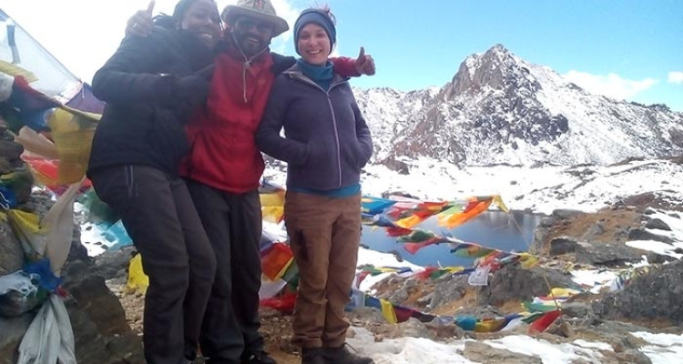
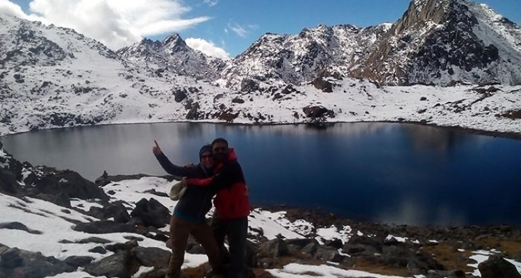
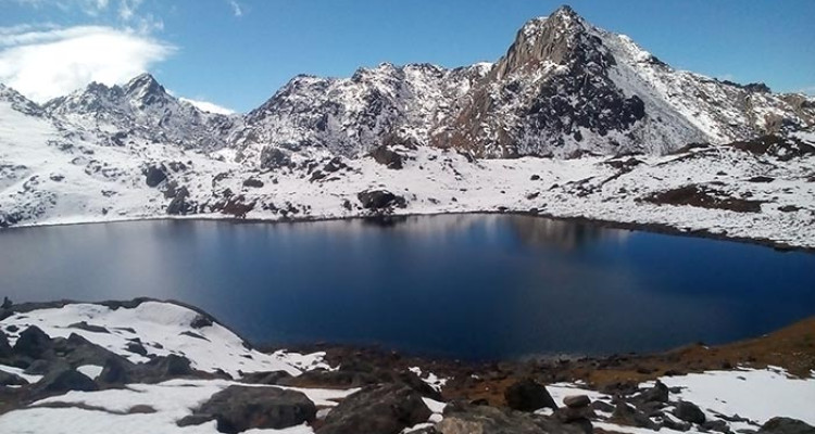
The trek starts from Besishahar and follows the traditional Annapurna Circuit trail up to Thorong Phedi, then diverts to Tilicho lake, which is the highest lake in the world at an altitude of 4,919 meters. It is considered one of the most beautiful and sacred lakes by the locals. After visiting Tilicho lake, the trail rejoins the traditional Annapurna Circuit trekking route and continues to Thorong-La pass which is the highest point of the trek at 5,416 meters. The pass offers panoramic views of the surrounding peaks and the Kali Gandaki valley.
The trek is considered to be challenging due to the high altitude and strenuous climbs, but it is also a rewarding experience for those who are up for a challenge. The trail is usually open from late September to November and from March to May. It’s advisable to have good physical and mental preparation, and also to have proper gear, as the trail can be cold and snowy.
Which trekking season is the best to go to Thorong-la pass and Tilicho Lake?
The best trekking season to go to Thorong-La Pass and Tilicho Lake is during the Autumn season, which is from September to November. During this time, the weather is clear and dry, making it the ideal season for trekking. The skies are usually clear, providing excellent views of the surrounding peaks and the trail is also less crowded. The temperature is also relatively warm during the day and cool at night, which is ideal for trekking.
Spring is also a good time to trek, which is from March to May. The weather is also clear and dry, although it can be a bit warmer than in autumn. The rhododendron forests will be in full bloom, providing an additional attraction to the trek. However, the trail can be crowded during this time as it is peak season.
It’s not recommended to trek in the monsoon season (June to August) or in the winter season (December to February) as the trail may be muddy, slippery and leeches are common, and the visibility can be poor due to the clouds and heavy rainfall. The trail can also be treacherous due to snow and ice, and the temperatures can be very cold, making it difficult to trek safely.
Food/meals during the trek:
During the Annapurna Tilicho Lake trek, you can expect to find a variety of food options at the teahouses and guesthouses along the trail. The menu typically includes local Nepali dishes such as Dal Bhat (lentils and rice), momos (Nepali dumplings), and curry dishes made with vegetables, chicken, or buffalo meat.
You will also find some continental dishes such as pasta, pizza, and sandwiches. Some teahouses also serve local bread such as roti and chapatti. Breakfast options include omelets, pancakes, and porridge.
You can also find some western-style snacks such as chocolate bars, instant noodles, and chocolate bars. It is also possible to find local fruits such as apples, oranges, bananas, and watermelons.
It’s worth noting that food options and their quality varies as you move away from the popular trekking routes and into more remote areas. It’s a good idea to carry some snacks like chocolates, nuts, dried fruits, and instant noodles as a backup.
It is important to keep in mind that it’s always better to avoid raw vegetables and fruits as they may not be washed properly or may be contaminated with water.
Weather and Temperature:
During the Thorong-La Pass and Tilicho Lake trek, the weather and temperature can vary greatly depending on the altitude and the season.
At lower elevations, temperatures can be quite warm during the day and cool at night, especially in the spring season. As you gain elevation, the temperatures will become cooler and can drop below freezing at night, especially at higher elevations.
In the Autumn season, the temperatures can be warm during the day and drop to freezing at night, with the possibility of snowfall on the pass. The trail is usually clear and dry during this time, making it the ideal season for trekking.
In the Spring season, the temperatures can be mild during the day and cool at night, with the possibility of snowfall in the pass. The rhododendron forests will be in full bloom, providing an additional attraction to the trek.
It’s important to be prepared for all types of weather when trekking in the high mountains and to have proper gear such as warm clothing, waterproof jacket, and pants, as well as good quality trekking boots, gloves, and a hat.
Tilicho Lake and Thorong La pass trekking Highlights:
Day 1: Arrival in Kathmandu (1,400 m/ 4,593 ft)
Day 2: Drive from Kathmandu to Besishahar (830 m/ 2,723 ft)
Day 3: Trek from Besishahar to Chame (2,710 m/ 8,891 ft)
Day 4: Trek from Chame to Pisang (3,300 m/ 10,827 ft)
Day 5: Trek from Pisang to Manang (3,540 m/ 11,614 ft)
Day 6: Acclimatization day in Manang
Day 7: Trek from Manang to Tilicho Base Camp (4,150 m/ 13,615 ft)
Day 8: Trek from Tilicho Base Camp to Tilicho Lake (4,919 m/ 16,138 ft)
Day 9: Trek from Tilicho Lake to Yak Kharka (4,000 m/ 13,123 ft)
Day 10: Trek from Yak Kharka to Thorong Phedi (4,600 m/ 15,091 ft)
Day 11: Cross Thorong-La Pass (5,416 m/ 17,078 ft) and trek to Muktinath (3,800 m/ 12,467 ft)
Day 12: Trek from Muktinath to Jomsom (2,700 m/ 8,858 ft)
Day 13: Drive from Jomsom to Pokhara
Day 14: Drive from Pokhara to Kathmandu
Day 15: Departure from Kathmandu
Day 1: Arrival in Kathmandu (1,400 m/ 4,593 ft)
Upon arrival at Tribhuvan International Airport in Kathmandu, our airport representative will greet you and escort you to a private vehicle for transportation to your hotel. Along the way, they will also point out a safe holiday adventure billboard. If you arrive after 4 pm, your pre-trip briefing will be conducted by our guide at the hotel. If you arrive before 4 pm, the briefing will take place at our office on the same day. During the briefing, you will meet your trek leader/guide and it is important to bring your passport, three passport-sized photos, and a copy of your travel insurance policy. At this time, any remaining balance for the trip must be paid and a legally binding trip form and non-liability disclaimer must be signed.
Day 2: Drive from Kathmandu to Besishahar (830 m/ 2,723 ft)
A drive from Kathmandu to Besishahar is a journey that takes you from the capital city of Nepal to the town of Besishahar, located in the Lamjung district. The drive typically takes around 6-7 hours, depending on the traffic and road conditions. The distance is around 160km. The route takes you through picturesque landscapes, passing through small towns and villages, and offering views of the Himalayan mountain range. The road is a mix of paved and rough roads. The elevation of Besishahar is 830m (2723ft) which is lower than Kathmandu which is at an elevation of 1300m. Once you reach Besishahar, you can explore the town, which is known for its beautiful temples and monasteries, as well as its traditional Newari culture.
Day 3: Trek from Besishahar to Chame (2,710 m/ 8,891 ft)
A trek from Besishahar to Chame is a journey that takes you through the beautiful Annapurna region of Nepal. The trek typically takes around 6-7 days, depending on your pace and the route you take. The distance between Besishahar and Chame is around 80km. The trail is a mix of steep inclines and descents, rocky terrain, and narrow paths. The trek starts with a drive from Besishahar to the trailhead, where you will begin your trek. The trail passes through lush forests, terraced fields, and traditional villages, offering stunning views of the Annapurna and Lamjung Himalayan ranges. As you trek higher in elevation, the vegetation changes to rhododendron forests, and finally to alpine meadows. Chame is the administrative headquarters of the Manang district, located at an altitude of 2710m (8891ft) and offers a great view of the Annapurna and Dhaulagiri ranges. Along the way, you will have the opportunity to learn about the culture and lifestyle of the local people and experience the unique biodiversity of the region.
Day 4: Trek from Chame to Pisang (3,300 m/ 10,827 ft)
The trek from Chame to Pisang is a journey that takes you from the village of Chame to the village of Pisang in the Annapurna region of Nepal. The trek typically takes around 2-3 days, depending on your pace and the route you take. The distance between Chame and Pisang is around 20km. The trail is steep and rocky, passing through lush forests, terraced fields, and traditional villages. As you trek higher in elevation, the vegetation changes to rhododendron forests and finally to alpine meadows. Pisang is located at an altitude of 3300m (10827ft) and offers great views of the Annapurna and Dhaulagiri ranges. Along the way, you will have the opportunity to experience the unique culture and lifestyle of the local people and the biodiversity of the region.
Day 5: Trek from Pisang to Manang (3,540 m/ 11,614 ft)
The trek from Pisang to Manang is a journey that takes you from the village of Pisang to the village of Manang in the Annapurna region of Nepal. The trek typically takes around 3-4 days, depending on your pace and the route you take. The distance between Pisang and Manang is around 40km. The trail is steep and rocky, passing through lush forests, terraced fields, and traditional villages. As you trek higher in elevation, the vegetation changes to rhododendron forests and finally to alpine meadows. Manang is located at an altitude of 3540m (11614ft) and offers great views of the Annapurna and Dhaulagiri ranges. This is a very important point, as this is the point above where AMS (Acute Mountain Sickness) is common, so trekkers are advised to take rest and acclimatize before continuing the trek. Along the way, you will have the opportunity to experience the unique culture and lifestyle of the local people and the biodiversity of the region.
Day 6: Acclimatization day in Manang
An acclimatization day in Manang is a day set aside during the trek to allow the body to adjust to the increasing altitude. Acclimatization is important because as the altitude increases, the air becomes thinner, and there is less oxygen available for the body to function properly. This can cause symptoms such as headaches, fatigue, and shortness of breath. To prevent altitude sickness, it is recommended to have an acclimatization day every 1000m of elevation gain.
Manang is located at an altitude of 3540m (11614ft) and it is considered a crucial point for acclimatization before continuing the trek to a higher altitude. During the acclimatization day, trekkers can spend time exploring the village, visiting local temples and monasteries, or simply relaxing and taking in the beautiful mountain views. They also can take a short hike to a nearby peak to help the body adjust to the altitude. It is also recommended to hydrate well and avoid alcohol and heavy meals during the process.
It is important to listen to your body and if you experience any symptoms of altitude sickness, it is important to descend immediately and seek medical help.
Day 7: Trek from Manang to Tilicho Base Camp (4,150 m/ 13,615 ft)
The trek from Manang to Tilicho Base Camp is a journey that takes you from the village of Manang to Tilicho Base Camp in the Annapurna region of Nepal. The trek typically takes around 4-5 days, depending on your pace and the route you take. The distance between Manang and Tilicho Base Camp is around 60km. The trail is steep and rocky, passing through lush forests, terraced fields, and traditional villages. As you trek higher in elevation, the vegetation changes to rhododendron forests and finally to alpine meadows. Tilicho Base Camp is located at an altitude of 4150m (13615ft) and offers great views of Annapurna and Dhaulagiri ranges.
It is important to note that this trek is considered an off-beaten path and it is not as popular as the main Annapurna Circuit Trek, which makes it more remote and challenging, with less infrastructure and facilities, and requires a high level of physical fitness and trekking experience. Along the way, you will have the opportunity to experience the unique culture and lifestyle of the local people, and the biodiversity of the region. Also, you will be able to experience Tilicho lake, which is considered one of the highest lakes in the world and offers a great view.
It is important to take necessary precautions and to be well prepared for this trek by carrying appropriate gear and clothing, and by being aware of the risks associated with high-altitude trekking, such as altitude sickness and cold weather.
Day 8: Trek from Tilicho Base Camp to Tilicho Lake (4,919 m/ 16,138 ft)
The trek from Tilicho Base Camp to Tilicho Lake is a journey that takes you from the Tilicho Base Camp to the Tilicho Lake, which is located in the Annapurna region of Nepal. The trek typically takes around 1-2 days, depending on your pace and the route you take. The distance between Tilicho Base Camp and Tilicho lake is around 15km. The trail is steep and rocky, and it requires a high level of physical fitness and trekking experience. As you trek higher in elevation, the vegetation changes to alpine meadows and glaciers. Tilicho Lake is located at an altitude of 4919m (16138ft) and offers great views of the Annapurna and Dhaulagiri ranges. It is considered one of the highest lakes in the world.
It is important to take necessary precautions and to be well prepared for this trek by carrying appropriate gear and clothing, and by being aware of the risks associated with high-altitude trekking, such as altitude sickness and cold weather. Also, it is important to note that this trek is considered as an off-beaten path and it is not as popular as the main Annapurna Circuit Trek, which makes it more remote and challenging, with less infrastructure and facilities. Along the way, you will have the opportunity to experience the unique culture and lifestyle of the local people, and the biodiversity of the region.
It is important to have a proper guide and to be well-informed about the weather conditions and trail conditions before starting the trek, and to have a proper plan and backup plan in case of emergencies.
Day 9: Trek from Tilicho Lake to Yak Kharka (4,000 m/ 13,123 ft)
The trek from Tilicho Lake to Yak Kharka is a journey that takes you from Tilicho Lake to Yak Kharka, which is located in the Annapurna region of Nepal. The trek typically takes around 1-2 days, depending on your pace and the route you take. The distance between Tilicho Lake and Yak Kharka is around 20km. The trail is steep and rocky, and it requires a high level of physical fitness and trekking experience. As you trek lower in elevation, the vegetation changes to alpine meadows and glaciers. Yak Kharka is located at an altitude of 4000m (13,123ft) and offers great views of the Annapurna and Dhaulagiri ranges.
It is important to take necessary precautions and to be well prepared for this trek by carrying appropriate gear and clothing, and by being aware of the risks associated with high-altitude trekking, such as altitude sickness and cold weather. Also, it is important to note that this trek is considered an off-beaten path and it is not as popular as the main Annapurna Circuit Trek, which makes it more remote and challenging, with less infrastructure and facilities. Along the way, you will have the opportunity to experience the unique culture and lifestyle of the local people, and the biodiversity of the region.
It is important to have a proper guide and to be well-informed about the weather conditions and trail conditions before starting the trek, and to have a proper plan and backup plan in case of emergencies.
Day 10: Trek from Yak Kharka to Thorong Phedi (4,600 m/ 15,091 ft)
The trek from Yak Kharka to Thorong Phedi is a journey that takes you from Yak Kharka to Thorong Phedi in the Annapurna region of Nepal. The trek typically takes around 1-2 days, depending on your pace and the route you take. The distance between Yak Kharka and Thorong Phedi is around 10km. The trail is steep and rocky, and it requires a high level of physical fitness and trekking experience. As you trek higher in elevation, the vegetation changes to alpine meadows and glaciers. Thorong Phedi is located at an altitude of 4600m (15091ft) and offers great views of the Annapurna and Dhaulagiri ranges.
It is important to take necessary precautions and to be well prepared for this trek by carrying appropriate gear and clothing, and by being aware of the risks associated with high-altitude trekking, such as altitude sickness and cold weather. Along the way, you will have the opportunity to experience the unique culture and lifestyle of the local people, and the biodiversity of the region.
It is important to have a proper guide and to be well-informed about the weather conditions and trail conditions before starting the trek, and to have a proper plan and backup plan in case of emergencies. Thorong Phedi is considered a crucial point for acclimatization before continuing the trek to the Thorong La Pass.
Day 11: Cross Thorong-La Pass (5,416 m/ 17,078 ft) and trek to Muktinath (3,800 m/ 12,467 ft)
The Thorong-La Pass is a high mountain pass located in the Annapurna region of Nepal. It sits at an elevation of 5,416 meters (17,078 feet) and is considered one of the most challenging and strenuous treks in the region. The trek to Thorong-La Pass typically starts in the town of Pokhara and goes through a variety of landscapes, including lush forests, steep inclines, and high-altitude plateaus. The pass itself is often covered in snow and can be extremely windy.
After crossing the pass, the trek continues to Muktinath, a sacred pilgrimage site for both Hindus and Buddhists. It is located at an elevation of 3,800 meters (12,467 feet) and is known for its 108 water spouts and two temples dedicated to Lord Vishnu. The trek to Muktinath is considered relatively easier than the trek to Thorong-La Pass, but it still requires good physical fitness and acclimatization to the high altitude.
Day 12: Trek from Muktinath to Jomsom (2,700 m/ 8,858 ft)
The trek from Muktinath to Jomsom is relatively short compared to the trek to Thorong-La Pass. Jomsom is located at an elevation of 2,700 meters (8,858 feet) and is the administrative center of the Mustang District. It is a popular destination for trekkers and hikers due to its proximity to the Annapurna and Dhaulagiri mountain ranges.
The trek from Muktinath to Jomsom is less challenging than the trek to Thorong-La Pass and typically takes 6 hours to Jomsom. It takes you through a dramatic transition of landscape, from the high-altitude desert of Mustang to the lush subtropical valley of Jomsom. The trail passes through charming villages, and terraced fields, and along the Kali Gandaki river. Along the way, you will have an opportunity to experience the unique culture and lifestyle of the local people.
Day 13: Drive from Jomsom to Pokhara
The drive from Jomsom to Pokhara is a scenic journey that takes you through a diverse range of landscapes and cultures. The distance between Jomsom and Pokhara is about 200 km and it takes about 8-10 hours by car.
The drive starts from Jomsom, a small town located in the Mustang district, and takes you through the Kali Gandaki River Valley. The valley is known for its stunning landscapes, including the Annapurna and Dhaulagiri mountain ranges, as well as its unique culture and lifestyle of the local people. The road is mostly unpaved and winding, so the journey can be a bit bumpy. You will pass through several small towns and villages along the way, offering an opportunity to see the traditional lifestyle of the local people.
As you get closer to Pokhara, the road becomes paved and the landscape changes to subtropical, with lush vegetation, terraced fields, and rivers. Pokhara is a popular tourist destination known for its natural beauty and adventure activities. The drive ends in Pokhara, a beautiful lakeside city that offers an array of accommodation, food, and entertainment options.
The drive from Pokhara to Kathmandu is a scenic journey that takes you through a diverse range of landscapes and cultures. The distance between Pokhara and Kathmandu is about 200 km and it takes about 6-7 hours by car or bus.
The drive starts from Pokhara, a beautiful lakeside city known for its natural beauty and adventure activities, and takes you through the lush subtropical landscape of the Annapurna region. The road is mostly paved and winding, so the journey can be a bit bumpy. You will pass through several small towns and villages along the way, offering an opportunity to see the traditional lifestyle of the local people.
As you get closer to Kathmandu, the road becomes more urbanized and the landscape changes to a more mountainous terrain. The drive ends in Kathmandu, the capital and largest city of Nepal. It is a vibrant city known for its rich history, culture, and architecture, as well as its temples, shrines, and monuments.
The drive from Pokhara to Kathmandu is a great way to end a trekking or adventure trip in Nepal, as it offers an opportunity to see the contrasts between the different regions of the country and to experience the diverse culture and lifestyle of the local people.
Day 15: Departure from Kathmandu- describe very shortly
Departure from Kathmandu typically involves traveling to the Tribhuvan International Airport, located about 6 km from the city center. The airport is the only international airport in Nepal and has regular flights to destinations around the world.
Before departing, travelers will need to check in for their flight and go through security and immigration formalities. It is advisable to arrive at the airport at least 3 hours before the scheduled departure time to allow enough time for these procedures.
| Start Date | End Date | Price In US Dollar($) | AVAILABILITY | Booking |
|---|
How difficult is the Thorong La Pass and Tilicho Lake trekking?
The Thorong La Pass and Tilicho Lake trekking is considered a challenging trek due to its high altitude and strenuous climb to the Thorong La Pass. It requires good physical fitness and acclimatization to the high altitude.
What is the best time to trek Thorong La Pass and Tilicho Lake?
The best time to trek Thorong La Pass and Tilicho Lake is between September and November when the weather is clear and the skies are mostly blue.
How long does it take to complete the Thorong La Pass and Tilicho Lake trek?
The Thorong La Pass and Tilicho Lake trek typically take around 18-21 days to complete, depending on the itinerary and the pace of the trek.
What is the highest altitude on the Thorong La Pass and Tilicho Lake trek?
The highest altitude on the Thorong La Pass and Tilicho Lake trek is Thorong La Pass at 5,416 meters (17,078 feet).
Are a guide and porter necessary for the Thorong La Pass and Tilicho Lake trek?
While it is possible to trek independently, hiring a guide and porter is recommended for the Thorong La Pass and Tilicho Lake trek as it can be challenging, especially at high altitudes.
How much does it cost to trek Thorong La Pass and Tilicho Lake?
The cost of the Thorong La Pass and Tilicho Lake trek varies depending on factors such as the itinerary, the number of days, and the services included, but it generally ranges from around $1000 – $2000.
What type of accommodation is available during the Thorong La Pass and Tilicho Lake trek?
Accommodation during the Thorong La Pass and Tilicho Lake trek is typically in teahouses or guesthouses, which offer basic facilities such as shared bathrooms and dining areas.
What are the permits required for the Thorong La Pass and Tilicho Lake trek?
The Thorong La Pass and Tilicho Lake trek requires TIMS (Trekkers’ Information Management System) and Annapurna Conservation Area Permit (ACAP)
Can I charge my electronic devices during the trek?
Electricity is available in most of the teahouses, but it is recommended to carry a power bank as it can be hard to find charging points in remote areas.
What should I pack for the Thorong La Pass and Tilicho Lake trek?
Some essential items to pack for the Thorong La Pass and Tilicho Lake trek include warm clothing, a good pair of hiking boots, a waterproof jacket and pants, a sleeping bag, a first aid kit, a water purification system, and a headlamp.
Safe Holiday Adventure Pvt. Ltd.
P.O.Box: 20065
Nayabazar-16,Khusibu,Kathmandu, Nepal
Cell: 00977 9849116284
Email: info@safeholidayadventure.com,
safeholidayadventure@gmail.com


We are associated with
We accept