28 Oct 2023 29 min to read
The Everest Base Camp trek itinerary is an important plan that helps you organize your journey to one of the most amazing places on Earth. This itinerary shows you what to do each day, where to go, and how far you will walk. It also helps you prepare for the changes in altitude, which is very important for staying healthy during the trek.
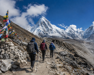
Usually, the trek starts with a flight from Kathmandu to Lukla, a small mountain town. From Lukla, you begin walking through beautiful forests, crossing rivers and suspension bridges, and visiting traditional Sherpa villages. Each day, the itinerary tells you how many hours you will walk and what sights to enjoy, like views of snow-capped peaks or colorful prayer flags.
Rest days are included in the itinerary to allow your body to adjust to higher altitudes, which reduces the risk of altitude sickness. The trek usually takes about 12 to 14 days, depending on your pace and stops.
Following a well-planned itinerary makes your trek safer, more enjoyable, and helps you experience the best of the Everest region. It ensures you don’t miss important highlights like Namche Bazaar, Tengboche Monastery, and, of course, the spectacular view at Everest Base Camp itself.
Here’s a sample Everest Base Camp Trek itinerary:

Starting Point: Kathmandu (1,350 meters), the capital city of Nepal.
Destination: Lukla (2,840 meters), gateway to the Everest region and the start of many treks, including Everest Base Camp.
Flight Duration: About 30 to 40 minutes by small airplane or helicopter.
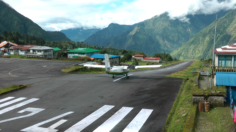
Airport Name: Tenzing-Hillary Airport, named after the first climbers to summit Mount Everest.
Runway: Short and sloped, only about 527 meters long, making the landing and takeoff tricky and exciting.
Flight Conditions: Flights depend heavily on weather; morning flights are usually safer because afternoon clouds and wind can cause delays.
Alternative Route: Some trekkers drive or take a bus from Kathmandu to Ramechhap (about 6–8 hours) and then fly from Ramechhap to Lukla to avoid Kathmandu’s busy airport.
Why Fly: Flying saves several days of hard trekking through the lowlands and hill roads.
View During Flight: Spectacular views of snow-capped mountains, including Everest, Lhotse, and Ama Dablam on a clear day.
Safety Tips: Flights can be canceled due to bad weather, so always allow extra days in your itinerary.
Lukla Town: A Small mountain village with shops, tea houses, and trekking gear shops, where you finalize permits and prepare for your trek.
Your trek from Lukla to Phakding starts after landing at the small but famous Tenzing-Hillary Airport in Lukla (2,840 meters). This airport is one of the most thrilling in the world, with its short runway and beautiful mountain views. After collecting your backpack and getting organized, your guide may take you to a nearby teahouse for breakfast or tea before starting the walk.
You begin the trek by passing through the Pasang Lhamu Memorial Gate, which marks the official start of the Everest Base Camp trail. Just after the gate, you will walk through the busy Lukla bazaar filled with small shops, tea houses, and local houses. The trail gently descends at first, making it an easy start. You will soon leave the busy part of Lukla and start walking through beautiful Sherpa farmland, where you can see potato fields, stone walls, and grazing yaks or dzopkos (yak-cow crossbreeds).
The path winds through a lovely forest of pine and rhododendron trees. You’ll also walk beside the Dudh Koshi River, a fast-flowing glacier river with a milky white color. Along the way, you will pass through small Sherpa villages like Chheplung and Thado Koshi, where you can take a break and enjoy the peaceful environment. In Chheplung, you may see local children playing and villagers working in the fields. Near Thado Koshi, there is a beautiful view of Mt. Kusum Kanguru, a striking double-peaked mountain.
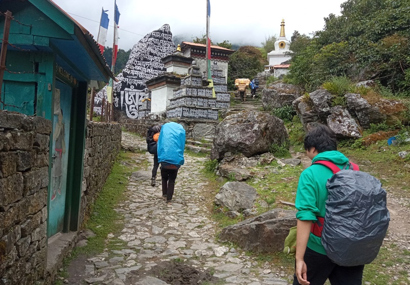
As you move ahead, you will cross your first suspension bridge, hanging high over the river. These bridges are safe and strong, decorated with colorful prayer flags. It’s a fun and exciting experience for most trekkers. Just after the bridge, the trail climbs gently again and takes you to Ghat village (2,530 m), where there are more teahouses, mani walls (stone walls with carved prayers), and small Buddhist chortens and monasteries. One of the highlights in Ghat is the beautifully painted mani stones and prayer wheels you can spin as you walk by, a tradition among Buddhist pilgrims.
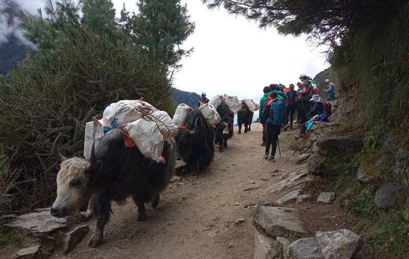
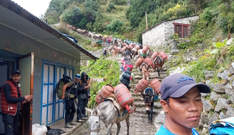
From Ghat, the trail becomes easier again. You walk on a pleasant path that follows the Dudh Koshi River. There are occasional short uphill and downhill sections, but nothing too steep. You may see donkey or yak caravans bringing goods to higher villages, so always keep to the uphill side when passing.
Before reaching Phakding, you pass a small Trekking Check Post, where your guide will register your permits. Just a short walk after the checkpoint, you cross another hanging bridge, and then a final short climb leads you to the quiet village of Phakding (2,610 m).
Phakding is a beautiful riverside village surrounded by green hills and snow-capped peaks in the distance. It has several cozy tea houses and lodges with gardens and terraces. You can rest, have lunch, and explore nearby places like the small monastery above the village or walk along the river.
This first day is a gentle warm-up for the days ahead, allowing you to get used to the walking rhythm and enjoy the peaceful Himalayan surroundings.
In the off-season (like December, January, February, June, July, and August), flights usually go directly from Kathmandu Airport (Tribhuvan International Airport) to Lukla Airport (Tenzing-Hillary Airport).
During peak trekking months (October, November, March, and April), most Lukla flights operate from Ramechhap’s Manthali Airport instead of Kathmandu. This change is made to avoid flight delays and traffic at Kathmandu airport.

Distance: Approximately 10 kilometers (6.2 miles)
Duration: About 5 to 6 hours of walking, depending on your pace and weather
Starting Elevation: Phakding at 2,610 meters (8,563 feet)
Ending Elevation: Namche Bazaar at 3,440 meters (11,286 feet)
Altitude Gain: Around 830 meters (2,723 feet)
Trail Difficulty: Moderate to challenging, due to the steep climb near Namche
The second day of the Everest Base Camp trek is longer and more challenging than the first. You will walk about 6 to 7 hours and gain around 800 meters of altitude. This is a big step up, both in terms of physical effort and excitement, as you begin to feel the real Himalayan adventure. The trail is full of beautiful nature, hanging bridges, Sherpa villages, and the first views of Mount Everest.
You start your day early from Phakding (2,610 meters), a peaceful village along the Dudh Koshi River. After breakfast, you follow the trail upstream along the river. The sound of the river, chirping birds, and fresh mountain air make the morning walk very pleasant. Soon, you cross a long suspension bridge decorated with prayer flags. These bridges are a unique part of the Everest trek.
After crossing the bridge, you reach the village of Toktok, followed by Benkar, both small and beautiful Sherpa settlements. You will see many stones, prayer wheels, and farms with potatoes and barley. The trail continues through a lovely forest filled with pine and rhododendron trees, with the sound of the river always nearby. On a clear day, you may get your first glimpse of Thamserku (6,608 m), a beautiful snow-covered mountain.
Next, you arrive at Monjo (2,835 meters), a quiet village where you take a short rest. Just beyond Monjo is the Sagarmatha National Park entrance, where your guide will show you your trekking permits and get them registered. There is also a small visitor center that has maps, pictures, and information about the Everest region.
From the national park checkpoint, the trail drops steeply down to the Dudh Koshi River, and you cross another suspension bridge. Then you walk along the riverbank and reach Jorsalle (2,740 meters). This is the last village before Namche Bazaar, so many trekkers stop here for lunch. There are a few teahouses and shops where you can eat and refill your water.
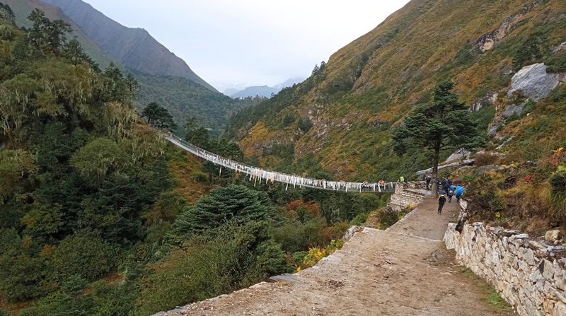
After Jorsalle, the real challenge begins. The trail becomes steeper as you follow the river, cross one more bridge, and then start climbing uphill through a dense pine forest. After a while, you reach the most famous hanging bridge on the trail—the Hillary Suspension Bridge. This high, long bridge hangs above the Dudh Koshi River and is often photographed. Crossing it is a thrilling experience!
Once across, the long uphill climb to Namche Bazaar begins. This part of the trail is tough, especially as you gain altitude. The path is steep and zig-zags through the forest, but it is well-made and wide. Along the way, you may see musk deer or Himalayan Thar if you’re lucky.
About halfway up, there is a viewpoint, and on a clear day, you can see Mount Everest (8,848 m) for the very first time, rising behind the ridge. It’s a magical moment that gives you the energy to keep climbing.
Finally, after a few more turns and a steady climb, you reach a checkpost just before Namche Bazaar, where your permits are checked again. From there, it’s a short walk to Namche Bazaar (3,440 meters)—the biggest Sherpa town in the Everest region.
Arrival at Namche Bazaar
Namche is built on a hillside in a horseshoe shape. It has colorful houses, bakeries, shops, cafés, trekking gear stores, banks, and even an internet café. It is the main trading and resting point for trekkers and locals. The views are incredible, and the atmosphere is lively yet peaceful.
Most trekkers stay two nights in Namche to rest and adjust to the altitude. It’s a great place to explore and get ready for the higher Himalayan trails ahead.

Acclimatization Day in Namche Bazaar — Trip Fact
Short hike distance: 4–6 km (round trip)
Trekking hours: 2 to 3 hours (easy/moderate pace)
Altitude gain: From 3,440 m (Namche Bazaar) to about 3,880 m (Everest View Hotel)
Purpose: Acclimatization and rest
Difficulty: Easy to moderate (mostly uphill on a short hike)
After a good sleep in Namche Bazaar, you begin your acclimatization day with breakfast at your teahouse. Then, you take a short but steep hike to Everest View Hotel (3,880 m). The trail goes uphill through pine forests and offers amazing mountain views. After 2 hours, you reach the hotel, one of the highest in the world. From its terrace, you can see Mount Everest, Lhotse, Ama Dablam, and other snow-covered peaks. You enjoy tea or coffee while relaxing in the fresh mountain air.
After resting, you return to Namche, which takes about 1.5 hours downhill. After lunch, you visit the Sagarmatha National Park Museum. It displays information about the local Sherpa culture, animals, plants, and Everest climbing history. Near the museum is a viewpoint with a statue of Tenzing Norgay, and if the weather is clear, you’ll see Everest again.
In the late afternoon, you have free time to explore Namche Bazaar. You can visit shops, bakeries, or the monastery. This is a good day to rest, buy gear, and enjoy the lively Sherpa town.
Sleeping at the same altitude helps your body adjust, making this day very important for the days ahead on the Everest Base Camp trek.
Namche Bazaar to Tengboche — Trek Fact
Distance: Approx. 10 km (6.2 miles)
Trekking hours: 5 to 6 hours
Altitude:
Start: 3,440 m (Namche Bazaar)
End: 3,860 m (Tengboche Monastery)
Terrain: Mixed uphill and downhill trails with some steep sections
Highlights: Scenic rhododendron forests, views of Everest, Ama Dablam, and other peaks, visit to famous Tengboche Monastery
Difficulty: Moderate
The trek from Namche Bazaar to Tengboche in the Khumbu region of Nepal is a captivating journey through the heart of the Himalayas. It is a segment of the popular trek to Everest Base Camp and offers trekkers a chance to immerse themselves in the breathtaking landscapes and unique culture of the region.
Starting from Namche Bazaar, a bustling Sherpa town situated at an altitude of 3,440 meters, the adventure begins. Namche serves as a vital acclimatization point, allowing trekkers to adjust to the increasing altitude before heading further into the mountains. The town is nestled in a natural amphitheater surrounded by towering peaks and provides a glimpse into the Sherpa way of life with its bustling markets and teahouses.
As you depart Namche Bazaar, the trail initially descends through a lush forest adorned with rhododendron and juniper trees. The descent leads to the picturesque village of Sanasa at an altitude of 3,600 meters. The path is filled with sights and sounds of nature, and the crisp mountain air invigorates the senses.
After Sanasa, the journey continues to Phunki Tenga, a charming settlement at an elevation of 3,250 meters. Here, the trekking path meets the convergence of two vital rivers, the Dudh Koshi and Imja Khola. To reach Phunki Tenga, you’ll cross a suspension bridge, an iconic feature of this region’s landscape. The village provides a serene stopover point, offering a taste of local hospitality and a moment to appreciate the beauty of the surrounding rivers and forests.
The final leg of the journey leads to Tengboche, perched at an altitude of 3,860 meters. Tengboche is renowned for its namesake monastery, the Tengboche Monastery, which is one of the most significant monastic institutions in the Khumbu region. The spiritual ambiance and the stunning panoramic views from Tengboche make it a highlight of the trek. Ama Dablam, Everest, and other majestic peaks can be admired from this vantage point, creating a sense of awe and reverence.
Throughout the trek, you’ll experience a dynamic mix of terrains, including both ascents and descents, while navigating dense forests and crossing suspension bridges. The trek requires careful acclimatization and preparedness for ever-changing weather conditions. Altitude and mountainous terrain present their challenges, and trekkers are advised to take their time, stay hydrated, and heed the guidance of experienced local guides.
The route from Namche Bazaar to Tengboche encapsulates the essence of the Himalayas, offering not only the allure of majestic mountains but also the cultural richness of the Sherpa people. It’s a journey that promises unforgettable moments in one of the most remarkable landscapes on Earth.
Distance: Approximately 11 km (7 miles)
Trekking time: Around 5 to 6 hours
Altitude:
Tengboche: 3,860 meters (12,664 feet)
Dingboche: 4,410 meters (14,470 feet)
Trail details: The trail ascends steadily through beautiful rhododendron and pine forests, crossing several suspension bridges over the Imja Khola river. The route offers spectacular views of Ama Dablam, Lhotse, and other peaks. The climb is moderate but gets steeper near Dingboche.
The trek from Tengboche to Dingboche is an enchanting and challenging journey that takes you deeper into the Khumbu region of Nepal. This segment of the Everest Base Camp trek offers trekkers a chance to experience the unique beauty of the Himalayan landscape, from lush forests to more arid terrain as you ascend to higher altitudes.
Starting from Tengboche, a spiritual and cultural center in the Khumbu region, the trail initially descends towards the small village of Debuche. The descent involves crossing a suspension bridge over the Imja Khola river. After crossing the river, you begin the ascent on the opposite side, gradually gaining altitude once again. Debuche is a serene village with tea houses and lodges, making it an ideal spot to take a break and refuel.
Continuing on your journey, the trail meanders through dense forests adorned with rhododendron and juniper trees. As you ascend, you’ll reach the village of Pangboche, another picturesque Sherpa settlement. Pangboche is known for its beautiful gompa (monastery), and it provides trekkers with an opportunity to explore the local culture and enjoy breathtaking mountain vistas.
Leaving Pangboche, the landscape gradually becomes more arid, and you’ll find yourself trekking through higher-altitude terrain. Somare is the next village you’ll come across on the trail, offering spectacular views of iconic peaks like Ama Dablam. The elevation at this point is around 4,000 meters, which requires careful acclimatization and pacing.
Further along the trail, you’ll encounter the villages of Orsho and Shomare. These settlements, at approximately 4,110 meters and 4,010 meters, respectively, are relatively small and provide essential teahouses where trekkers can rest, eat, and replenish their energy.
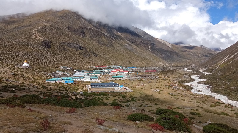
Dingboche, your ultimate destination, lies at an altitude of around 4,410 meters. It’s a significant acclimatization point on the Everest Base Camp trek. Dingboche is a picturesque village with fields of barley and potatoes surrounded by stone walls to protect crops from the harsh mountain winds. From Dingboche, you’ll have stunning views of Lhotse, Island Peak, and other towering peaks. It’s essential to take your time acclimatizing in Dingboche before continuing your trek to even higher elevations toward Everest Base Camp.
The journey from Tengboche to Dingboche combines natural beauty, cultural richness, and the thrill of ascending to higher altitudes in the Himalayas. It’s a segment of the trek that offers trekkers a chance to immerse themselves in the wonders of the region while taking the necessary precautions to ensure a safe and enjoyable adventure.
Altitude: 4,410 m (14,470 ft)
Hike to Nangarkhang Hill: 3 km (1.9 miles) round trip, 1.5–2 hours
Hike to Chhukung: 8 km (5 miles) round trip, 3–4 hours
Moderate uphill terrain
Purpose: Acclimatization and mountain views
Dingboche, a picturesque village nestled in the heart of the Khumbu region of Nepal, is an essential acclimatization stop for trekkers and climbers on their journey to Everest Base Camp. Perched at an altitude of approximately 4,410 meters (14,468 feet), Dingboche offers a stunning backdrop of towering Himalayan peaks, including Ama Dablam and Lhotse. This idyllic settlement serves as a crucial acclimatization point, allowing adventurers to adjust to the thinning air and avoid altitude-related ailments. During your stay in Dingboche, you can embark on a short but rewarding hike to Nangarkhang Hill. This hill, situated on the outskirts of the village, offers a breathtaking panoramic view of the surrounding mountains and valleys. The hike to Nangarkhan Hill not only aids in acclimatization but also provides a serene escape into the Himalayan wilderness. As you traverse the rocky paths and breathe in the crisp mountain air, you’ll find yourself immersed in the natural beauty and tranquility of this high-altitude haven. Dingboche is not only a place to acclimatize but a destination that encapsulates the serene grandeur of the Himalayas, making it an integral part of any trekking or mountaineering expedition in the Everest region.
Distance: 8 km (5 miles)
Trekking time: 4–5 hours
Altitude gain: from 4,410 m (Dingboche) to 4,940 m (Lobuche)
Terrain: Rocky and gradual uphill
Highlights: Views of Thukla Pass, glaciers, and peaks like Pumori and Nuptse
The trail from Dingboche to Lobuche in the Everest region of Nepal is a challenging yet awe-inspiring journey that takes trekkers through the heart of the Himalayas. As you leave Dingboche, you embark on a gradual ascent through a high-altitude desert landscape, characterized by scattered shrubs and a barren, rocky terrain. The trail offers spectacular vistas of the surrounding peaks, with Ama Dablam and Lhotse dominating the horizon.
As you continue your trek, you’ll reach the village of Dughla, also known as Thukla, which serves as a common stopover point for trekkers. Here, you’ll find several memorials dedicated to climbers and mountaineers who lost their lives in the Everest region. The most prominent of these memorials is the Scott Fischer Memorial, dedicated to one of the climbers who perished in the tragic 1996 Everest disaster. The memorials serve as a poignant reminder of the risks and challenges that come with high-altitude mountaineering.
Leaving Dughla, the trail becomes steeper and more challenging as you ascend towards Lobuche. You’ll pass through a section of the trail known as the “Dughla Pass,” which features a collection of small stone memorials honoring climbers who lost their lives on Everest and other nearby peaks. These memorials stand as a testament to the indomitable spirit of adventure and exploration that draws people to this region.
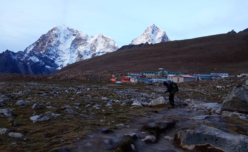
The final stretch of the trail takes you to the village of Lobuche, which is situated at an altitude of around 4,940 meters (16,207 feet). This remote and rustic village is often used as a stopover point before trekkers continue their journey to Everest Base Camp. The journey from Dingboche to Lobuche, with its memorials and stark mountainous landscapes, is a physically demanding yet spiritually enriching experience, providing trekkers with a deep connection to the history and majesty of the Everest region.

Distance: 7 km (4.3 miles)
Trekking time: 3 to 4 hours
Altitude: Starts at 4,940 m (Lobuche), ends at 5,164 m (Gorak Shep)
Terrain: Mostly rocky trail with some gentle uphill sections. The path can be rough and stony, requiring careful footing.
Highlights:
Stunning views of towering peaks like Pumori (7,161 m), Nuptse (7,861 m), and the Khumbu Glacier.
Close approach to the base of the Khumbu Icefall area (though not accessible).
Panoramic vistas of the Everest massif and surrounding Himalayan giants.
You pass through the small settlement of Gorak Shep, which is the last stop before Everest Base Camp and Kala Patthar.
The trek from Lobuche to Gorak Shep and on to Everest Base Camp is one of the most exhilarating and iconic segments of the Everest Base Camp trek. Here’s a description of the journey:
Lobuche to Gorak Shep (5,164 meters/16,942 feet): The trail from Lobuche to Gorak Shep takes you through a desolate, high-altitude terrain, characterized by rocky paths and scattered boulders. As you ascend, you’ll have awe-inspiring views of the Khumbu Glacier and the surrounding peaks. Gorak Shep, a small settlement located at an altitude of 5,164 meters, serves as the last outpost before reaching Everest Base Camp. The trek to Gorak Shep is challenging due to the high altitude and thin air, and it can take several hours. Upon reaching Gorak Shep, you’ll have a brief rest and prepare for the final leg of your journey.
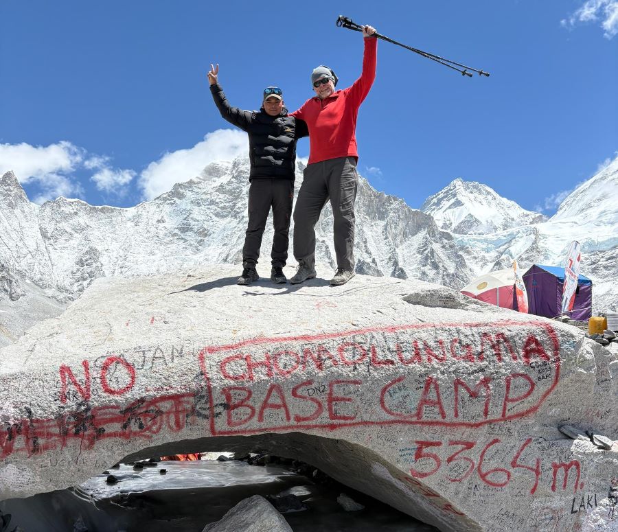
Gorak Shep to Everest Base Camp (5,364 meters/17,598 feet): The trail from Gorak Shep to Everest Base Camp is both thrilling and demanding. It’s a relatively flat walk, but the high altitude can make it quite strenuous. The landscape is stark and rugged, with the Khumbu Icefall and the formidable walls of Everest looming in the distance. As you approach Everest Base Camp, you’ll be surrounded by the iconic sights of colorful prayer flags, expedition tents, and the ice-covered surface of the Khumbu Glacier. The sense of achievement as you step into Everest Base Camp, at an elevation of 5,364 meters, is unparalleled. It’s a place where dreams and reality converge, and trekkers often take time to reflect on the history and significance of this location.
Everest Base Camp back to Gorak Shep: After spending some time at Everest Base Camp, taking in the incredible surroundings and perhaps chatting with climbers and expedition teams, you’ll begin your journey back to Gorak Shep. The return hike, while mostly downhill, can still be physically demanding due to the high altitude. You’ll retrace your steps along the Khumbu Glacier, with the mighty Everest as your constant companion. Once you arrive back in Gorak Shep, you can rest, reflect on your remarkable accomplishment, and enjoy the breathtaking views of the sunset over the Everest massif.
This trek is a once-in-a-lifetime experience, allowing you to be in the heart of the world’s tallest mountains and to witness the incredible beauty and challenges of the Everest region. It’s a journey that embodies the spirit of adventure and exploration in the Himalayas.

Distance: 3.5 km (round trip) Gorak Shep–Kala Patthar; 15 km Kala Patthar–Pheriche
Time: 4–6 hrs (to Kala Patthar and back); 5–6 hrs (to Pheriche)
Altitude: 5,164 m (Gorak Shep) → 5,545 m (Kala Patthar) → 4,371 m (Pheriche)
Terrain: Steep rocky climb to Kala Patthar; mostly downhill to Pheriche
Highlights: Best Everest views from Kala Patthar; scenic descent through alpine forest to Pheriche
The journey from Gorak Shep to Kala Patthar to Pheriche is a challenging and breathtaking trekking experience in the Khumbu region of Nepal. Gorak Shep, situated at an elevation of 5,164 meters (16,942 feet), serves as a common base camp for trekkers and climbers attempting to reach the Everest Base Camp. The path from Gorak Shep to Kala Patthar is a significant highlight of the trek. Kala Patthar, standing at a lofty 5,545 meters (18,192 feet), is renowned for offering one of the most iconic and panoramic views of Mount Everest, as well as the surrounding Himalayan peaks. The hike to Kala Patthar is a strenuous uphill climb, and the high altitude makes it even more challenging. Trekkers often start their ascent in the pre-dawn darkness to witness the sunrise over Everest, casting a warm golden glow on the world’s tallest mountain.
Kala Patthar provides an unparalleled vantage point to see the majestic Everest and several other towering peaks in the region, including Lhotse, Nuptse, and Pumori. The stunning beauty of the mountains against the backdrop of the sunrise is a memory that trekkers cherish for a lifetime. After enjoying the awe-inspiring scenery at Kala Patthar, trekkers typically descend back to Gorak Shep for a well-deserved breakfast.
The journey continues as you make your way from Gorak Shep to Pheriche, which is situated at a lower altitude of 4,280 meters (14,042 feet). The descent from Gorak Shep to Pheriche involves walking through the rugged terrain of the Khumbu region. As you descend, the landscape gradually changes, and you’ll notice the vegetation becoming more lush and varied, with rhododendron forests and picturesque meadows dotting the trail. Pheriche is a charming and peaceful village that serves as a popular stopover for trekkers on their way to and from Everest Base Camp. It’s a place where trekkers can rest and acclimatize to the lower altitude before continuing their journey.
The transition from the lofty heights of Kala Patthar to the lower altitude of Pheriche offers a stark contrast in scenery, from barren, snow-capped peaks to a more hospitable environment with a warmer climate. Pheriche provides a glimpse into the local Sherpa culture, with its monasteries, prayer flags, and hospitable teahouses, where trekkers can savor hearty meals and engage with the local community. Overall, this trek from Gorak Shep to Kala Patthar to Pheriche is an adventure that combines challenging ascents, breathtaking views, and a cultural experience, making it a memorable and enriching part of the Everest Base Camp trek.
Distance: About 19.5 km (12 miles)
Duration: Around 6 to 7 hours of walking
Altitude: Descends from 4,240 m (Pheriche) to 3,440 m (Namche Bazaar)
Trail: Mix of downhill and uphill sections, passing through forests and rivers with some suspension bridges
Highlights: Walk through traditional Sherpa villages like Pangboche and Tengboche, enjoy stunning mountain views along the way
Starting the morning in Pheriche, a serene village perched at around 4,371 meters, you awaken to the crisp mountain air and panoramic views of the Himalayan peaks. After a hearty breakfast, you set out on the retraced journey to Namche Bazaar, initially descending through a landscape that alternates between rocky paths, yak pastures, and rhododendron-filled forests. The descent can be taxing on the knees, requiring the support of trusty trekking poles.
As you progress, you reach Tengboche, a charming village located at approximately 3,867 meters. The Tengboche Monastery, a cultural gem of the region, offers a serene respite where you may have the chance to witness a religious ceremony. Further down the trail, a series of tea houses and lodges provide a well-deserved lunch break, offering an opportunity to savor local Nepali dishes.
Crossing the Dudh Koshi River over suspension bridges provides thrilling moments, with the river gorge and lush hillsides serving as a visual feast. The most strenuous part of the day begins after the last suspension bridge: the challenging ascent back to Namche Bazaar. While physically demanding, the familiarity of the route and the anticipation of reaching Namche keep you motivated, and the colorful prayer flags along the path add a spiritual touch to the landscape.
Upon reaching Namche Bazaar after a full day of trekking, you’re greeted by the lively atmosphere of this vibrant town. It’s a place to unwind and explore, with numerous shops, cafes, and bakeries to enjoy. Alternatively, you can choose to relax in your lodge, soaking in the breathtaking mountain scenery surrounding Namche Bazaar. This retraced journey from Pheriche to Namche Bazaar combines the physical challenges of the trek with the familiar beauty of the Himalayas, making it a truly memorable and rewarding experience in the Everest region of Nepal.
Distance: Around 18 km (11 miles)
Time: About 6 to 7 hours of walking
Altitude: Drops from 3,440 m (Namche Bazaar) to 2,860 m (Lukla)
Trail: A mix of downhill paths with some short uphill sections, passing through forested areas and several suspension bridges
Highlights: Trek through lively Sherpa villages, cross the scenic Dudh Koshi River, and experience the lively atmosphere as you reach Lukla, the gateway to the Everest region
The trekking route from Namche to Lukla is a breathtaking journey through the heart of the Khumbu region in Nepal. Starting in the vibrant town of Namche Bazaar at an elevation of 3,440 meters, trekkers embark on a scenic adventure. Namche is a bustling hub for trekkers and climbers and is the ideal place to acclimatize to the altitude. From Namche, the trail winds through rhododendron forests, offering stunning views of the snow-capped peaks of the Himalayas. One of the highlights along the way is the picturesque Tengboche at 3,860 meters, home to the famous Tengboche Monastery, which provides a spiritual and serene break in the journey. As the trail descends, you’ll cross the Dudh Koshi River and follow the winding path through charming villages, eventually reaching Lukla, the gateway to the Khumbu region. This town at an altitude of 2,800 meters marks the end of the trek and is where many trekkers and climbers begin their Himalayan adventures. The journey from Namche to Lukla is not only physically rewarding but also offers a rich cultural and natural experience amidst the towering peaks of the Everest region.
Distance: Approximately 135 kilometers (84 miles)
Flight Duration: Around 25–30 minutes
Altitude: Lukla (2,860 m) → Kathmandu (1,400 m)
Airlines: Tara Air, Sita Air, Summit Air, Simrik Air
Aircraft: Twin Otter, Dornier (STOL-certified)
Cost: Approximately $228
Schedule: Morning flights (6:00–10:00 AM) are preferred due to better weather conditions
Weather: Flights are subject to delays or cancellations due to rapidly changing weather in the Himalayas
Alternative Route: During peak seasons, flights may operate from Ramechhap Airport instead of Kathmandu
You’ll catch a flight from Lukla back to Kathmandu. This short flight provides one last opportunity to take in the stunning mountain views, weather permitting. Once back in Kathmandu, you can relax, celebrate your achievement, and explore the vibrant city.
The Everest Base Camp trek is an incredible journey through some of the world’s most beautiful and challenging terrain. The trekking hours can vary, but you should expect to walk 5-7 hours on average each day, with longer days on the way to Everest Base Camp and Kala Patthar.
Throughout the trek, it’s essential to be mindful of your health, stay hydrated, and listen to your body. Altitude sickness is a real concern, and it’s crucial to acclimatize properly and have an experienced guide with you to ensure a safe and enjoyable trekking experience. The altitudes mentioned for each location are approximate and can vary slightly depending on the specific route you take.
Introduction: Short Everest Base Camp Trek Overview The Short Everest Base Camp Trek Overview offers
Continue Reading
The Manaslu Trail Race is a world-class Himalayan trail running event that takes runners deep into t
Continue Reading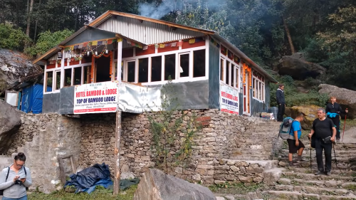
Introduction The trek from Syabrubesi to Lama Hotel is the first major walking section of the Langta
Continue Reading
Nepal is one of those rare destinations that stays in your heart long after your trip ends. From the
Continue Reading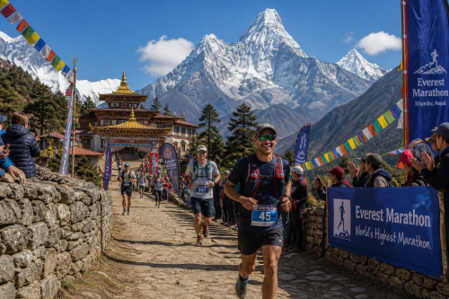
Running a marathon is a challenge almost anywhere on Earth. But running one at the foot of Mount Eve
Continue Reading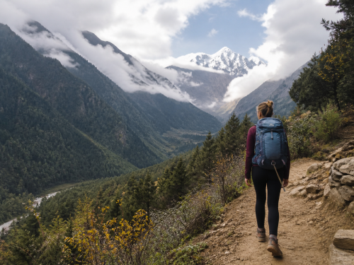
Female solo trekking in Langtang Valley has become an increasingly popular choice for women seeking
Continue Reading